OCCASIONALLY it’s necessary to make a bit of noise to get a job done, and that is exactly what happened with the recent upgrade of the navigation buoys in the Rous Channel. After a concerted effort with multi-agency support, the upgrade finally took place and the outcome has been considerably better than many people anticipated.
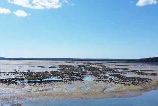
The biggest problem with the Rous is the sandbanks are mobile, and it is an area that requires programming flexibility and vigilance to maintain safe navigation marks. Sadly, that had been lacking for well over a year and the delayed response was not a COVID issue. Navigation updated
However, let’s give credit to Maritime Safety Queensland in recognition of the good job they have done. Also, a big thanks to Marine Parks because without their input and assistance in the process, the boating community would not have received such a good outcome.
The first item of importance to readers is that the Rous Channel itself is now well marked, and for the time being the navigation aids are accurate – given the changing nature of the sandbanks. As important is now an additional channel is clearly marked with red and green buoys, which cuts out the long tortuous horseshoe bend in the Rous and provides a relatively straight line.Navigation updated
This links the western end of the Rous Channel near the junction with the Little Ships Channel to the existing green buoys at the eastern end of the Rous. This is a massive game changer – this marked channel defines an area where a natural channel formed, previously declared as a go-slow turtle and dugong protection area.
It provides far more direct access to Amity and South Passage Bar, and now there is less risk of grounding on the sandbanks within the horseshoe area of the Rous. As this new channel is greater than 2m deep at low tide, the marking of its boundaries with both green and red buoys was strongly supported and insisted on by Marine Parks in the multi-agency process.Navigation updated
We can now all lawfully stay on the plane through there, providing we remain within the easy to read marked boundaries on both sides of this channel. Outside the whole of this new marked channel is still a go-slow area. This latter comment is critical for skippers to comply with, as being able to stay on the plane in the new channel is a major concession granted to all of us in a sensitive area of the Marine Park.Navigation updated
No doubt, there will be a need for tweaking the location of a few of the buoys over time, but it goes to demonstrate what can be achieved when there is a multi-agency approach and a determined drive to get the job done. It is a big bonus for recreational and small commercial vessel operators who traverse the Rous Channel. Navigation updated
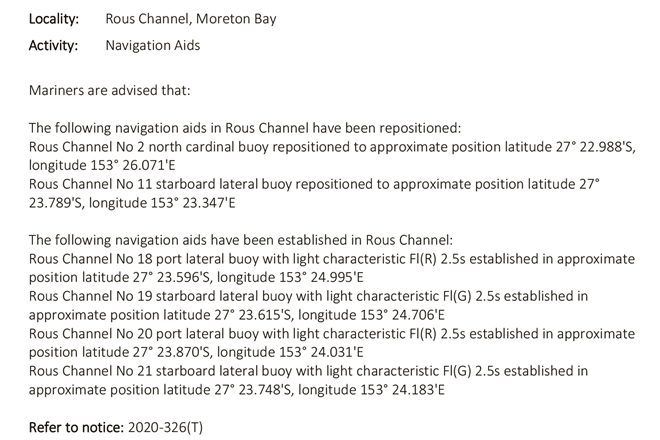
Getting the info out there is not quite so easy and no doubt there will be eventual upgrades to electronic charts available from the various manufacturers. There are notices to mariners with latitude and longitude locations on MSQ’s website.Navigation updated
Or you can do what I did recently – go for a run through the area and mark all of the buoys in both channels as waypoints (using red and green icons, which I keep exclusively for marking navigation aids to prevent any confusion).
Safe boating as we wind down to Christmas.