
Find fish aggregating devices in Queensland
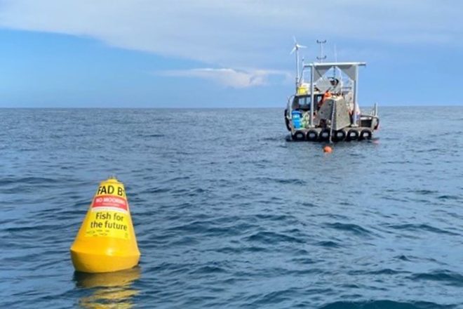
Queensland FADs GPS locations: Fish aggregating devices are human-made structures anchored offshore that attract fish, making them easier to catch so you can have a great fishing experience.
To start with, 25 surface FADs were deployed off South East Queensland, from Fraser Island to the Gold Coast. These FADs have been popular with fishers, with great catches of mahi mahi reported.
As part of the next stage of the program, four surface FADs were deployed off Weipa, three surface and four all-water FADs off Wide Bay Burnett and 12 subsurface FADs off South East Queensland. Additional FADs are also being considered for other parts of Queensland.
Fish attracted to FADs
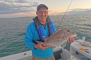
Most fish attracted to the FADs are seasonal pelagic fish, which travel in the warm water delivered by ocean currents. Species caught around the FADs include mahi mahi, wahoo, tuna, cobia, mackerel and billfish.
Mahi mahi are the most common species of fish caught around the FADs and are the perfect sport fish:
- They have a remarkable growth rate, known to grow as fast as 7cm in a week.
- Adult fish can grow to almost 200cm (weighing up to 40kg).
- They can be sexually mature as early as 6 months of age and reproduce at a high rate.
- They are relatively short-lived – they rarely live past 2 years of age.
Check out the interactive map for the locations of all the Queensland FADS. Queensland FADs GPS
Below is a list with GPS marks.
Click here for details on the initial FAD program.
Fish aggregating devices are deployed in the following locations all year round: Queensland FADs GPS locations
South east Queensland
| FAD type | FAD location | Latitude (DDM) | Longitude (DDM) | Distance from nearest access point (nm) | Depth of water (m) |
|---|---|---|---|---|---|
| Surface FAD | FAD 1: Gold Coast 24s | 27° 59.268’S | 153° 31.747’E | 6 from Gold Coast Seaway | 46 |
| Surface FAD | FAD 2: Gold Coast 50s | 27° 55.790’S | 153° 45.198’E | 16 from Gold Coast Seaway | 85 |
| Surface FAD | FAD 3: Gold Coast 36s | 27° 48.408’S | 153° 37.472’E | 12 from Gold Coast Seaway | 68 |
| Surface FAD | FAD 11: Gold Coast 36s | 28° 03.047’S | 153° 39.480’E | 16 from Gold Coast seaway | 65 |
| Surface FAD | FAD 12: Gold Coast 36s | 27° 56.040’S | 153° 38.331’E | 11 from Gold Coast seaway | 64 |
| Surface FAD | FAD 12B: Gold Coast 36s | 27° 55.462’S | 153° 37.571’E | 11 from Gold Coast seaway | 64 |
| Surface FAD | FAD 12C: Gold Coast 36s | 27° 55.029’S | 153° 38.267’E | 11 from Gold Coast seaway | 64 |
| Surface FAD | FAD 13: Gold Coast 50s | 27° 44.368’S | 153° 44.314’E | 20 from Gold Coast Seaway | 86 |
| Surface FAD | FAD 14: Gold Coast 36s | 27° 40.460’S | 153° 36.166’E | 18 from Gold Coast Seaway | 66 |
| Surface FAD | FAD 15: Point Lookout offshore | 27° 23.448’S | 153° 40.623’E | 12 from South Passage bar | 104 |
| Surface FAD | FAD 4: Stradbroke offshore | 27° 17.029’S | 153° 37.672’E | 9.5 from South Passage Bar | 83 |
| Surface FAD | FAD 16: Moreton offshore | 27° 11.097’S | 153° 36.894’E | 13 from South Passage bar | 108 |
| Surface FAD | FAD 5: Moreton offshore | 27° 05.797’S | 153° 34.177’E | 14 from Comboyuro Point | 89 |
| Surface FAD | FAD 17: Cape Moreton offshore | 26° 59.654’S | 153° 33.585’E | 5 from Cape Moreton | 108 |
| Surface FAD | FAD 6: Bribie offshore | 26° 55.735’S | 153° 31.775’E | 12 from Comboyuro Point | 100 |
| Surface FAD | FAD 18: Wide Caloundra | 26° 44.758’S | 153° 27.189’E | 18 from Mooloolaba | 60 |
| Surface FAD | FAD 19: Mooloolaba 18nm | 26° 36.144’S | 153° 25.765’E | 17 from Mooloolaba | 49 |
| Surface FAD | FAD 7: Mooloolaba 10nm | 26° 35.908’S | 153° 19.686’E | 10 from Mooloolaba | 55 |
| Surface FAD | FAD 7B: Mooloolaba 10nm | 26° 34.999’S | 153° 18.665’E | 10 from Mooloolaba | 56 |
| Surface FAD | FAD 7C: Mooloolaba 10nm | 26° 35.099’S | 153° 20.727’E | 10 from Mooloolaba | 56 |
| Surface FAD | FAD 8: Mooloolaba east | 26° 34.259’S | 153° 33.796’E | 24 from Mooloolaba | 101 |
| Surface FAD | FAD 20: Noosa | 26° 22.700’S | 153° 14.300’E | 9 from Noosa | 52 |
| Surface FAD | FAD 9: Noosa | 26° 15.558’S | 153° 19.754’E | 14 from Noosa | 55 |
| Surface FAD | FAD 10: Double Island offshore | 25° 53.075’S | 153° 21.907’E | 16 from Wide Bay Bar | 57 |
| Surface FAD | FAD 21: Fraser Island offshore | 25° 41.269’S | 153° 22.616’E | 17 from Wide Bay bar | 51 |
| Subsurface FAD | SFAD 1A: Gold Coast continental shelf | 27° 55.542’S | 153° 53.764’E | 25 from Gold Coast Seaway | 256 |
| Subsurface FAD | SFAD 1B: Gold Coast continental shelf | 27° 54.555’S | 153° 54.108’E | 25 from Gold Coast Seaway | 273 |
| Subsurface FAD | SFAD 1C: Gold Coast continental shelf | 27° 55.425’S | 153° 54.765’E | 26 from Gold Coast Seaway | 306 |
| Subsurface FAD | SFAD 2A: Point Lookout continental shelf | 27° 25.720’S | 153° 49.764’E | 19 from South Passage Bar | 250 |
| Subsurface FAD | SFAD 2B: Point Lookout continental shelf | 27° 24.894’S | 153° 50.489’E | 20 from South Passage Bar | 258 |
| Subsurface FAD | SFAD 2C: Point Lookout continental shelf | 27° 25.738’S | 153° 51.278’E | 20 from South Passage Bar | 290 |
| Subsurface FAD | SFAD 3A: Cape Moreton continental shelf | 27° 01.074’S | 153° 45.918’E | 22 from Comboyuro Point | 269 |
| Subsurface FAD | SFAD 3B: Cape Moreton continental shelf | 27° 00.412’S | 153° 46.696’E | 23 from Comboyuro Point | 280 |
| Subsurface FAD | SFAD 3C: Cape Moreton continental shelf | 27° 01.088’S | 153° 47.563’E | 23 from Comboyuro Point | 295 |
| Subsurface FAD | SFAD 4A: Mooloolaba continental shelf | 26° 40.491’S | 153° 40.111’E | 29 from Mooloolaba | 233 |
| Subsurface FAD | SFAD 4B: Mooloolaba continental shelf | 26° 39.887’S | 153° 40.786’E | 29 from Mooloolaba | 244 |
| Subsurface FAD | SFAD 4C: Mooloolaba continental shelf | 26° 40.709’S | 153° 41.170’E | 30 from Mooloolaba | 252 |
Wide Bay Burnett
| FAD type | FAD location | Latitude (DDM) | Longitude (DDM) | Distance from nearest access point (nm) | Depth of water (m) |
|---|---|---|---|---|---|
| Surface FAD | FAD F1: Rooney Point, Fraser Island | 24° 48.296’S | 153° 05.638’E | 31 from Urangan | 34 |
| Surface FAD | FAD F2: Fraser Island offshore | 24° 37.897’S | 153° 24.348’E | 8 from Sandy Cape | 54 |
| Surface FAD | FAD F3: Fraser Island offshore | 24° 58.062’S | 153° 32.673’E | 11 from Waddy Point | 54 |
| All-water FAD | FAD B1a: Bundaberg offshore | 24° 39.163’S | 152° 32.925’E | 10 from Burnett Heads | 25 |
| All-water FAD | FAD B1b: Bundaberg offshore | 24° 39.265’S | 152° 33.012’E | 10 from Burnett Heads | 25 |
| All water FAD | FAD B1c: Bundaberg offshore | 24° 39.355’S | 152° 32.922’E | 10 from Burnett Heads | 25 |
| All water FAD | FAD B1d: Bundaberg offshore | 24° 39.280’S | 152° 32.835’E | 10 from Burnett Heads | 25 |
Far North Queensland
| FAD type | FAD location | Latitude (DDM) | Longitude (DDM) | Distance from nearest access point (nm) | Depth of water (m) |
|---|---|---|---|---|---|
| Surface FAD | FAD G1: Weipa | 12° 58.959’S | 141° 17.009’E | 36 from Weipa | 30 |
| Surface FAD | FAD G2: Weipa | 12° 54.711’S | 141° 22.625’E | 29 from Weipa | 30 |
| Surface FAD | FAD G3: Weipa | 12° 48.671’S | 141° 23.665’E | 25 from Weipa | 30 |
| Surface FAD | FAD G4: Weipa | 12° 49.903’S | 141° 32.594’E | 18 from Weipa | 21 |


Are the Fads still out of Bundaberg